Route 66 - Photography
Showing posts with label Brief 03 - Route 66. Show all posts
Monday, 18 May 2015
Thursday, 27 November 2014
Brief 03 - Route 66 Design
Route 66
For the brief i wanted to make sure i knew which parts of the publication would cover which information. I looked on some websites to find the best route which was the most original so i could keep it simplistic.
The route i will use - starting:
- Chicago - Illinois
- Missouri
- Oklahoma
- Texas
- New Mexico
- Arizona
- Los Angeles - California.
This theme is based on the states i will then find the most interesting places with in the states to use for the publication.
MAP
I decided on starting with the map that will come separate to the publication and also featured in side of the publication.
America vector-
I drew a line from where Illinois is on the map to California.
I used a rounded type and then added the states underneath.I also added the route 66 icon underneath the names.
I next added colour to the design although i am bulky newsprint i felt it was going to be bit dull without colour.
I tried a variety of colours , But i felt they were to much for the design and it should be simplistic.
I also decided to take the Route 66 logo off the map as its obvious where the places are with the little points.
Publication:
Trying different images i felt this one was slightly too dark.
Layout 1:
Layout 2:
Layout 3:
Layout 4:
Layout 5:
Layout 6:
Layout 7:
The second page featured an image of Chicago Illinois the first place the Route 66 starts and on the left hand page the information about that state.
Still on the same state i next used another large image and put it on the left hand side large scale. The opposite page i used a smaller image which i had flush against the side of the page.
For the second Missouri page i used a large scale image and dragged it over the center.
Full bleed image:
Full bleed image
Map design:
Full bleed image
New mexico bio info and two images
Large image stretched over double page spread:
Arizona:
California:
Full bleed image:
Binding:
I used saddle stitch to bind the booklet but because of how it printed you could see some of the image through the other side. There was no way around the issue unless was to get the publication reprinted externally. Due to the printer in the digital dungeon over set printing.
I still tried to bind the publication the best i could but the printing left it slightly out.
Wednesday, 26 November 2014
Brief 03 - Research Content
BRIEF 03 - ROUTE 66
U.S. Route 66 (US 66 or Route 66), also known as the Will Rogers Highway and colloquially known as the Main Street of America or the Mother Road, was one of the original highways within the U.S. Highway System. Route 66 was established on November 11, 1926, with road signs erected the following year. The highway, which became one of the most famous roads in America, originally ran from Chicago, Illinois, through Missouri, Kansas, Oklahoma, Texas, New Mexico, and Arizona before ending at Santa Monica, California, covering a total of 2,448 miles (3,940 km). It was recognized in popular culture by both the hit song "(Get Your Kicks on) Route 66" and the Route 66 television show in the 1960s.
Route 66 served as a major path for those who migrated west, especially during the Dust Bowl of the 1930s, and it supported the economies of the communities through which the road passed. People doing business along the route became prosperous due to the growing popularity of the highway, and those same people later fought to keep the highway alive in the face of the growing threat of being bypassed by the new Interstate Highway System.
Route 66 underwent many improvements and realignments over its lifetime, and it was officially removed from the United States Highway System on June 27, 1985, after it had been replaced in its entirety by the Interstate Highway System. Portions of the road that passed through Illinois, Missouri, New Mexico, and Arizona have been designated a National Scenic Byway of the name "Historic Route 66", which is returning to some maps. Several states have adopted significant bypassed sections of the former US 66 into the state road network as State Route 66.
Imagery/Content:
The Red Brick Road in Auburn is truly exceptional. Indeed, Route 66's original surfacing is seldom seen anywhere. Here, it is decorated with large red bricks on a long stretch running between Auburn and Farmersville. This amazing road - use caution if driving on it - is still used by some locals.
Missouri:
Devil's Elbow steel bridge was laid down in 1923 over the Big Piney River. The structure, which can still be crossed by car, appears as a mist-clad ghost early in the morning against the Ozarks isolated forest area. Not surprisingly, it was the scene of several fatal accidents in the heyday of Route 66.
Above: Historic Bradbury Bishop Deli, Webb City, Missouri.
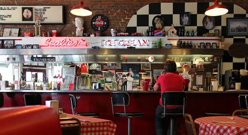
In the tradition of Route 66, this historic soda fountain mixes crushed ice and soda for the delight of children ... and of grown-ups too! In the past, these establishments created their own sodas but this tradition is slowly but steadily fading in favor of the ubiquitous fast food chains.
Oklahoma:
Mid point high way.
New Mexico:
Wigwam Motel, Route 66, Arizona.
California:
New Mexico:
Above: 66 Diner in Albuquerque, New Mexico.
This is probably the most beautiful Diner on Route 66. Simply called "66 Diner", its rounded-profile building lies at the center of a large parking lot whose streetlights evoke its past splendor. This iconic architectural style of the 40s, the "streamlined style", was once prevalent on Route 66 although few identical buildings have been so remarkably restored.
Arizona:Wigwam Motel, Route 66, Arizona.
California:
Subscribe to:
Posts (Atom)